Geopolitical gravity and blanks on the BRI map; or why what is missing really matters
Author: Galen Murton (James Madison University)
When thinking about the “downstream effects of the BRI,” Nepal comes quickly to mind. As both a hydrological basin of great rivers descending from Himalayan massifs and the Tibetan Plateau and a site of widespread infrastructure development significantly financed by Beijing, much moves from China into Nepal. Flows of water and synthetic garments; capital investment and political alliances – Chinese stuff is increasingly ubiquitous throughout Nepal. In no uncertain terms, the Belt and Road has accelerated the movement of these things – commodities and ideologies, energy and power. However, it is not the BRI as physical infrastructure that gets things done in Nepal; rather, like so many places elsewhere, the BRI instead functions as an instrument with discursive force, an imaginary that underwrites promises of modernity and motivates particular political activity.
It goes without saying that the BRI imposes major downstream effects even when such projects have no material form. Across Nepal, the Belt and Road has assumed a near omni-presence in development speak, a conspicuous articulation that generates and reproduces its own infrastructural power. Political leaders invoke the BRI to inspire national constituents and amplify state agendas from chambers of power, and even more desperately when on the electoral stump. At the same time, village leaders looking for long awaited post-disaster recovery also enunciate the exceptional construction capacity of China to help Nepal “build back better.” Tired of waiting for their own government or inefficient international alliances to act on reconstruction, many across Nepal point to Beijing and the BRI as a hopeful panacea to deliver development that’s been too long deferred.
Nepal has been part of the BRI movement since prior periods of Beijing’s erstwhile One Belt, One Road program. Beginning with formal dialogue in 2015, Nepal officially signed onto the Belt and Road in May 2017 with a proposal of 35 BRI development projects for the country. Primarily focused on construction in the energy and transport sectors as well as the creation of new “power corridors” and special economic zones (Murton & Lord 2020), Nepal’s original BRI vision estimated investment levels upwards of USD $10 billion. However, after Beijing balked at Kathmandu’s sky-high requests for BRI investment to the country, protracted negotiations brought Nepal’s aspirational BRI development target down to a select 9 key projects centred around circulatory transportation and energy infrastructures. Complimenting this BRI framework for Nepal, Kathmandu and Beijing also reached agreements at the Second Belt and Road Forum in April 2019 to coordinate new policy procedures for greater trade and transport connectivity. Most importantly, this entails the formulation of the Nepal-China Trans-Himalayan Multi-Dimensional Connectivity Network. Articulated as a bi-lateral agenda, this project prioritizes the operationalization of six economic corridors between Nepal and China with enhanced border facilities for trade and security as well as advanced transport infrastructure (Murton & Plachta 2021). However, belying the substantial discursive traction that the BRI has gained in Nepal, the very construction projects comprising this trans-Himalayan infrastructural agenda are consistently rendered as blanks on any BRI map.
Why, one might ask, are such high-profile development initiatives almost always absent from any map? While the BRI is very much a thing in Nepal – and a very big thing at that – it nevertheless remains invisible to broader international infrastructural cartographies. It is the tension of this paradox in Nepal that I want to explore here – the ubiquity of the BRI in national and discursive terms on the one hand, and the conspicuous invisibility of the BRI in cartographic terms on the other. Over the course of this analysis, we might also ask not only what is the point of this paradox, but what does it actually do?
Taking this observation as a critical starting point and in dialogue with previous contributions to the Transformations blog, this installment aims to think further “into” the BRI by illuminating the importance of Belt and Road cartographic representation – or its lack thereof. As Tim Oakes writes in “The BRI as an Exercise in Infrastructural Thinking,” good work is necessary to fill in many blank spots about the BRI – both qualitatively and cartographically. Building on previous empirically grounded, ethnographically attentive analyses of the impacts as well as implications of the BRI (Oliveira et al 2020; Sidaway et al 2020), a critical cartography also helps to advance efforts to theorize the infrastructural. In other words, what happens if the maps of BRI infrastructure themselves become a unit of analysis?
To map or not to map?
To be sure, there is no official map of the Belt and Road Initiative. The BRI is an idea, not a thing; a discursive vision rather than a coherent project. It is a policy agenda comprising major transportation infrastructures like roads and railways as well as education and humanitarian enterprises in the shape of schools and hospitals; even more, it also includes the development of broader mobile connections via telecommunication networks and diplomatic relationships. Like other infrastructural things, the BRI is both material and social, at once physical and always political. As a dynamic and ever-evolving project of global ambition motivated by Chinese ideologies of “going out” ever further (Yeh & Wharton 2016) the BRI cannot be mapped as a two-dimensional cartographic still-life. And yet, despite this expansive ambiguity, the BRI is repeatedly reified by a range of political actors and economic analysts who identify and promote the Belt and Road as a development project that will connect and modernize the world like never before. From Chinese Communist Party (CCP) cadres to activists in rural Nepal, the BRI continues to get work done by its name alone.
A pioneer in the discursive reading of maps as texts, the eminent critical cartographer J.B. Harley asserted that “it is better to begin from the premise that cartography is seldom (but not always) what cartographers say it is” (Harley 2001, 6). Bringing post-structuralist critique to bear on cartography, Harley argued that it is imperative to recognize and amplify particular “cartographic silences” in order to fully understand the power of maps. When reading BRI maps through these analytical lenses, if “that which is absent from maps is as much a proper field of enquiry as that which is present” (Harley 2001, 58), what then are we to make of the geographic blindspots (Harris 2013) located in such centrally important spaces of China’s foremost project of the 21st century?
While a singular map of the BRI may well be impossible to produce, it is surely no accident that an official map does not exist. A trove of reports, agreements, plans, and documents fill the website of the PRC’s official Belt and Road Portal, and yet this state-led mouthpiece of the BRI nevertheless neglects to map its eponymous self. Of course, this is in no way accidental. As Narins and Agnew argue (2019), a “missing map” allows the BRI to exist and operate as both concrete and ethereal, a “useful fuzziness” that makes the BRI appear inevitable but at the same time flexible (if not also wholly uncertain). Having already committed over $USD 1 trillion toward a myriad number of infrastructure projects comprising the BRI (Lai et al 2020), the CCP could surely build a sophisticated GIS platform to document, track, and project the latest and greatest aspects of the Initiative. But this is not underway, and it is unlikely to happen. As Oakes goes on to say, “The hole in the middle of the Belt and Road – a hole where there should have been plans and policies [and a map] – was intentional. Where actual content might be expected to be clarified and laid-out, there was instead a sort-of “fill in the blank” space. The Belt and Road was only ever meant to be a vague idea, a notion, a gesture, the beginning of a sentence waiting to be completed by someone else…We all love filling in the blank” (Oakes 2021).
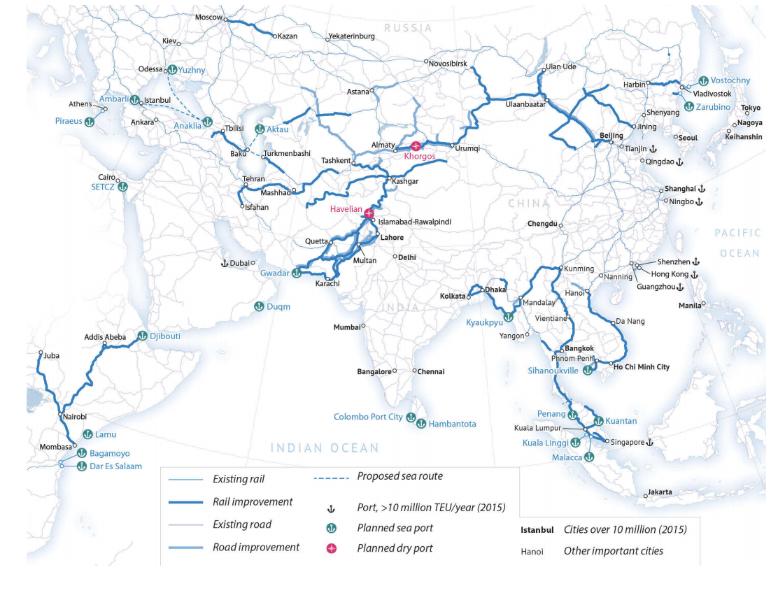
Despite the fact that no official BRI map exists, a great number of unofficial BRI maps circulate around the world; that is, in Harley’s formulation, there are indeed many “other maps” besides those belonging strictly to the state. In the case of the BRI, nearly all of these proliferating maps emphasize the six major “Economic Corridors” comprising the Silk Road Economic Belt; still other maps prioritize the “Maritime Silkroad” as a host of sea-lanes running from the South China Seas to the Atlantic and Artic Oceans and all places in between. For example, a quick look at two widely circulated and oft-cited maps produced by MERICS and the LeidenAsiaCentre illustrate the geographical contexts of some of these “other maps.”
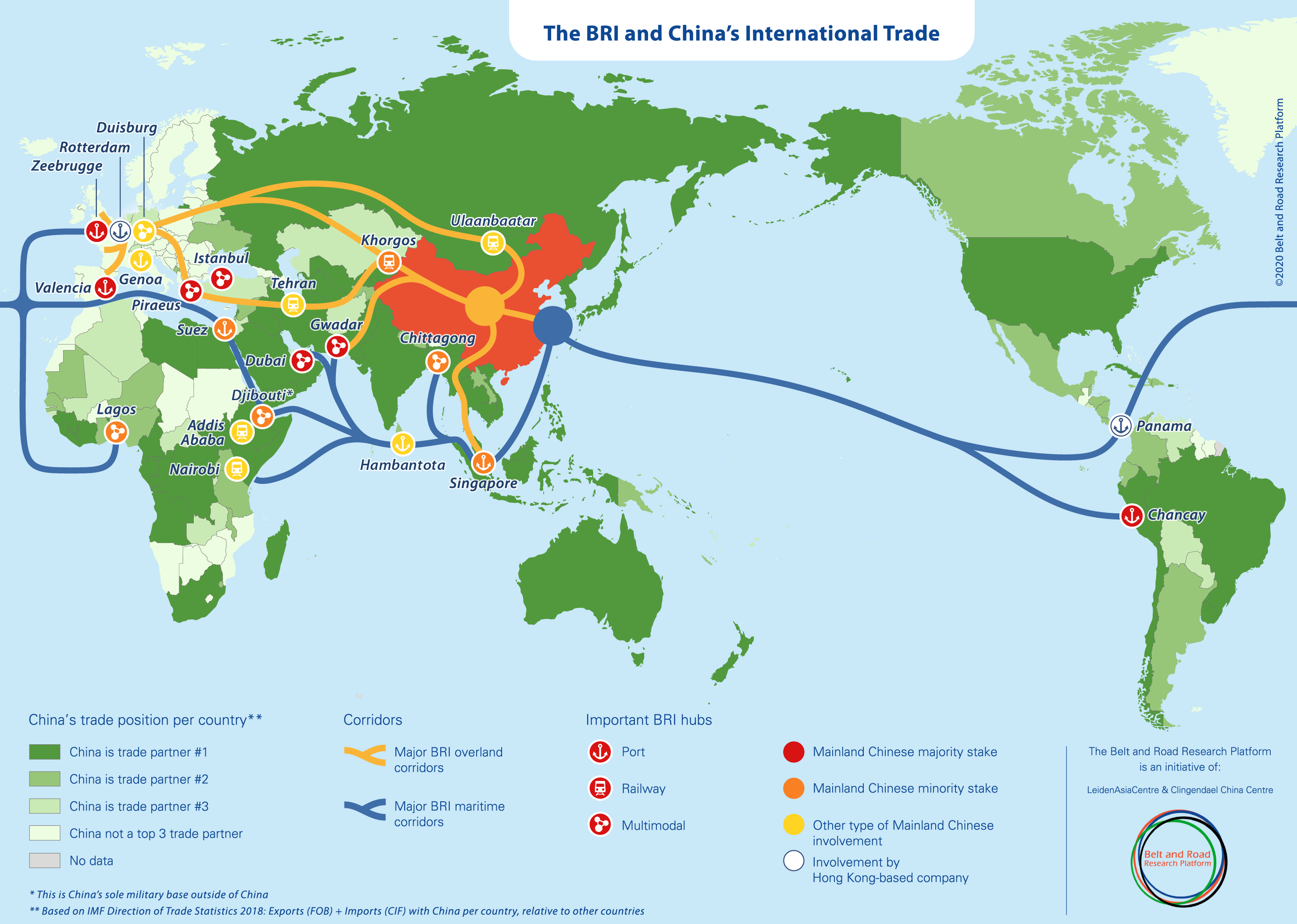
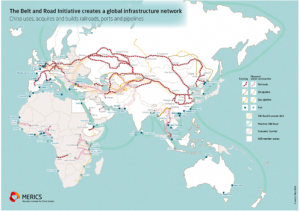
MERICS 2018 Leiden Asia Centre 2021
These popular maps are consistent in two key ways when it comes to cartographic invisibility. First, the maps emphasize the primary corridors and major development priorities of the BRI such as the China-Pakistan Economic Corridor (CPEC), the Bangladesh-China-India-Myanmar Economic Corridor (BCIM-EC), the New Eurasian Landbridge, and the notoriously indebted Hambantota seaport in Sri Lanka. Second, the maps largely ignore other important development projects in regions where the presence of the BRI is hardly invisible. More importantly, BRI programs in these “invisible regions” are in fact located within close proximity to the primary BRI development corridors. In the case of the paradox posed above, a close look at Nepal, Tibet, and the wider Himalaya region suggests that nothing much is going on there with respect to the BRI and that it is best rendered a mere a blank on the map – an empty space in between the greater commitments to corridor-making going on, for example, in Pakistan and Burma.
And yet, the presence of the BRI is hardly invisible or nonexistent on the ground across the Himalaya. The so-called Sky Train extension of the Qinghai-Tibet railroad from the Tibetan Plateau down into Nepal is hardly an unknown or irrelevant project. Indeed, it is a central piece of the nine Belt and Road projects that the Government of Nepal signed with the Chinese Communist Party in 2019. Beyond the “Sky Train” and the eight other BRI projects in Nepal, many more BRI initiatives exist in proximate areas of South Asia and beyond. From Nepal and Tibet to Bangladesh and the Maldives, a vast majority of BRI programs remain missing from the map. And that, one might argue, is not only highly problematic but in fact a strategically effective form of territorial logic employed by China today.
Still other cartographies drafted for econometric political risk assessments and international development planning further reproduce these infrastructural blindspots. Both the newly stylized World Bank BRI “subway” map (World Bank 2019) and the more statistically analytical cartography (Reed & Trubetskoy 2020) perpetuate the conspicuous invisibility of Nepal, Tibet, and the broader Himalaya region in the BRI frame (see below). On the one hand, China is time and again shown to be a leading force for development between Pakistan and the Caspian region as well as along the eastern seaboard of the African continent and throughout peninsular Southeast Asia, among many other spaces. Corridors into Mongolia, Russia, and Central Europe continue to recycle the great Silk Road tropes, as Beijing would have it (Sidaway & Woon 2017). But what, then, is going on in Nepal, and what happens when myriad projects across Tibet and the Himalaya are always rendered in this negative register of empty space?
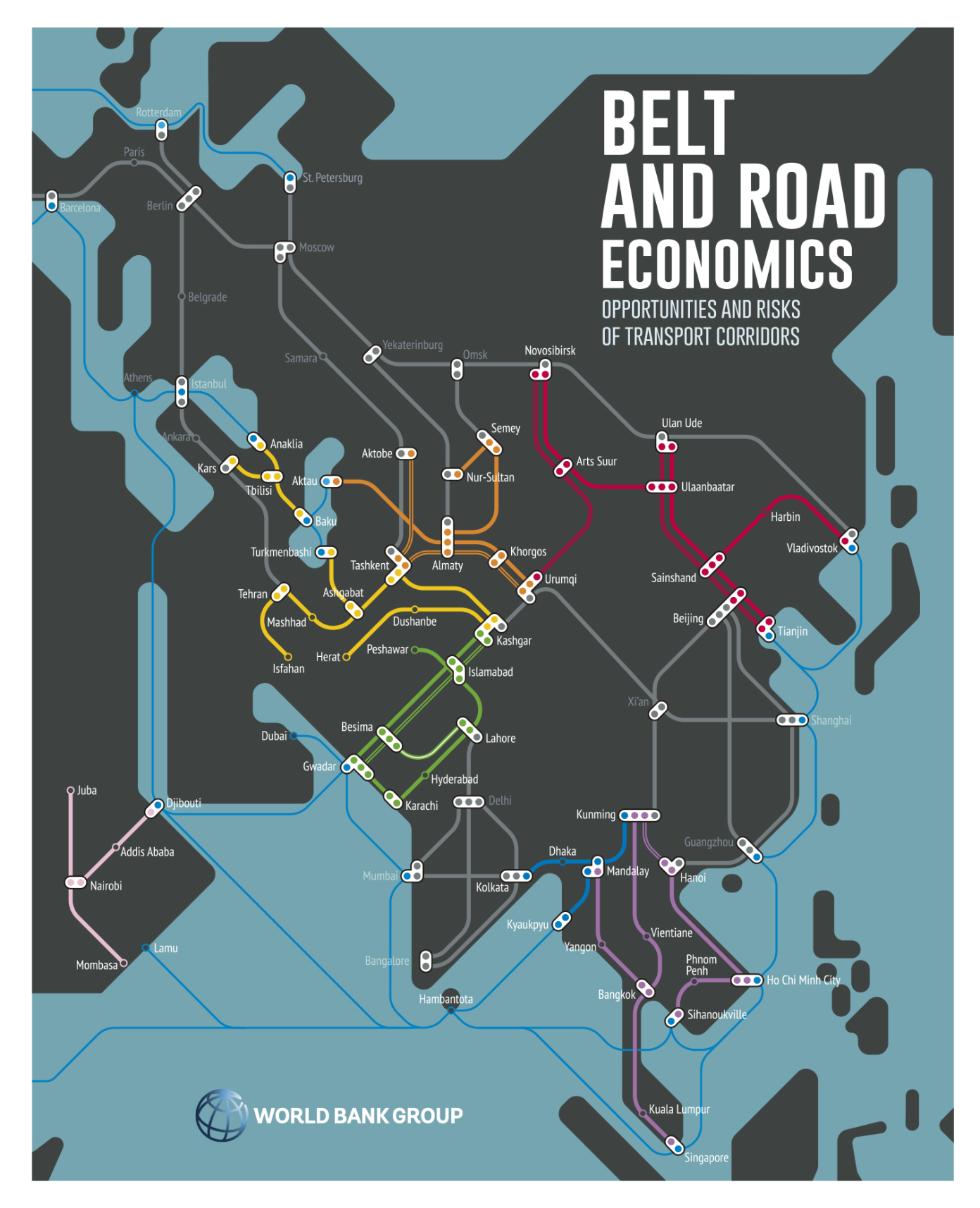
World Bank Group, 2019.
Reed & Trubetskoy 2020
The power of blank spaces
In Rethinking the Power of Maps, Denis Wood proposes that maps are and do all kinds of political things, including: “maps do work;” “maps operate effectively;” “maps leverage words;” “maps apply social forces;” and “maps convert energy to work by linking things in space” (Wood 2010, 1). Arguing that maps are in fact (if not nothing more than) a “discourse function” that advance the power and interests of the central state, Wood’s post-structuralist critique reminds us of the ways that BRI maps – and the lack thereof of an official BRI map – enable the CCP to communicate cartographically and leverage socio-political power through the broader discursive currency of the BRI.
Of course, no shortage of ink has been spilled on mapping the BRI, but little of that ink has belonged to Beijing nor has much been spent filling in infrastructure development projects across Nepal. From think tanks and leading media outlets to academic journals, corporate consultants, and the World Bank, maps of the BRI will continue to abound. While the details of planned BRI roads, rails, sea-lanes, and other transport infrastructures appear to be increasing in cartographic granularity and real-time accuracy, BRI infrastructures that cross the Tibetan Plateau and descend the Himalaya range downstream into South Asia remain all but absent from the vast majority of cartographic analyses.
Taking the mapping of BRI development as a place and process of inquiry, critical cartography can be productively put to work with the “infrastructural inversion” (Rippa, Murton & Rest 2020) to illuminate and highlight what ordinarily appears invisible in Belt and Road contexts. Such analyses are necessary to help us see how the BRI operates to extend and communicate China’s spatial power through the infrastructure of maps themselves. As the BRI expands both materially and discursively from Beijing to innumerable points around the world, critical examinations must continue to inquire into the many ways in which BRI programs are imagined, implemented, and mapped across a range of scales. To be sure, “China’s BRI is not a monolithic program designed in Beijing and imposed upon others. Rather, it is better understood as a bundle of intertwined discourses, policies, and projects that sometimes align and are sometimes contradictory” (Oliveira et al. 2020). Keeping these relational and contested processes in mind, it is important to recognize how unmapped BRI development projects – particularly in the form of roads and railways crisscrossing the Himalaya between Tibet and Nepal – nevertheless help to accomplish territorializing tasks for China today.
References
Harley, J.B. (2001). The new nature of maps. The Johns Hopkins University Press.
Harris, T. (2013). Geographical diversions: Tibetan trade, global transactions. University of Georgia Press.
Lai, Karen, Lin, Shaun & Sidaway, James. (2020). Financing the Belt and Road Initiative (BRI): Research agendas beyond the “debt-trap” discourse, Eurasian Geography and Economics, 61(2), 109-124. DOI: 10.1080/15387216.2020.1726787
Murton, Galen & Lord, Austin. (2020). Trans-Himalayan power corridors: Infrastructural politics and China’s Belt and Road Initiative in Nepal. Political Geography 77(102100). DOI: 10.1016/j.polgeo.2019.102100
Murton, Galen & Plachta, Nadine. (2021 forthcoming). China in Nepal: On the politics of Belt and Road development in South Asia. In Joseph Chinyong Liow, Liu Hong, & Gong Xue (Eds), Unpacking the Belt and Road Initiative. Edward Elgar Publishing.
Narins, Thomas & Agnew, John. (2019). Missing from the map: Chinese exceptionalism, sovereignty regimes and the Belt Road Initiative. Geopolitics 25(4), 809-837. DOI: 10.1080/14650045.2019.1601082
Oliveira, Gustavo, Murton, Galen, Rippa, Alessandro, Harlan, Tyler & Yang Yang. (2020). China’s Belt and Road Initiative: Views from the ground. Political Geography 82(102225). DOI: 10.1016/j.polgeo.2020.102225
Reed, Tristan & Trubetskoy, Alexander. (2020). Assessing the Value of Market Access from Belt and Road Projects. Policy Research Working Paper 8815. The World Bank Group. Available from: http://documents1.worldbank.org/curated/en/333001554988427234/pdf/Assessing-the-Value-of-Market-Access-from-Belt-and-Road-Projects.pdf
Rippa, Alessandro, Murton, Galen, & Rest, Matthäus. (2020). Building Highland Asia in the 21st century. Verge: Studies in Global Asias 6(2), 83-111. DOI: 10.5749/vergstudglobasia.6.2.0083
Sidaway, James and Woon, Chih Yuan. (2017). Chinese narratives on “One Belt, One Road” (一带一路) in geopolitical and imperial contexts. The Professional Geographer 69 (4): 591–603.
Sidaway, James, Rowedder, Simon, Woon, Chih Yuan, Lin, Weiqiang, & Pholsena, Vattana. (2020). Introduction: Politics and spaces of China’s Belt and Road Initiative. Environment and Planning C: Politics and Space 38(5), 795-802. DOI: 10.1177/2399654420911410
Wood, Denis. (2010). Rethinking the power of maps. Guilford Press.
World Bank, The. (2020). Belt and Road Economics. The World Bank Group.
Yeh, Emily & Wharton, Elizabeth. (2016). Going west and going out: Discourses, migrants, and models in Chinese development. Eurasian Geography and Economics 57(3): DOI: 10.1080.15387216.2016.1235982